
|
Understanding Extreme Geohazards: The Science of the Disaster Risk Management Cycle
European Science Foundation Conference
November 28 to December 1, 2011, Sant Feliu de Guixols, Spain
|


|
|
PICTURE CONTEST
The pictures displayed here were submitted for a picture contest in connection with the ESF Conference. Each participant was invited to submit the favorite geohazards picture.
If you want to use any of the pictures below, please note the relevant copyright information. To get higher resolution images (if available), please click on the picture.
Maria Bostenaru Dan
|
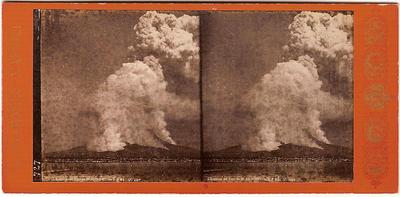
Submission by: Maria BOSTENARU DAN, "Ion Mincu" University of Architecture and Urbanism, Bucharest, Romania
The picture: The picture represents the eruption of Vesuvius on April 26, 1872, at
3 p.m., as seen from Naples, on stereo card, by photographer Giorgio
Sommer (1834-1914).
This is my favorite picture because: In 2010 I had a support grant from the Canadian Centre of Architecture to do research on photography of disasters from the 19th century. I wrote for their "Scholar Choice" an article about stereo photography by then, refering to the fire in Portland (Maine). I think that it is important to know how people used to think in 3D in the 19th century, and also that this kind of photos were used as souvenir, and were taken by artists in their portofolio, and not only for technical reasons or for the media. I considered it representative because it is also a volcano "in action".
Copyright information: This image is in the public domain because its copyright has expired. This applies to Australia, the European Union and those countries with a copyright term of life of the author plus 70 years. Available at
wikipedia.
Reference: The photographer is Giorgio Sommer, a renowned German photographer who
settled to Naples in the 19th century.
|
Marie Crovisier
|
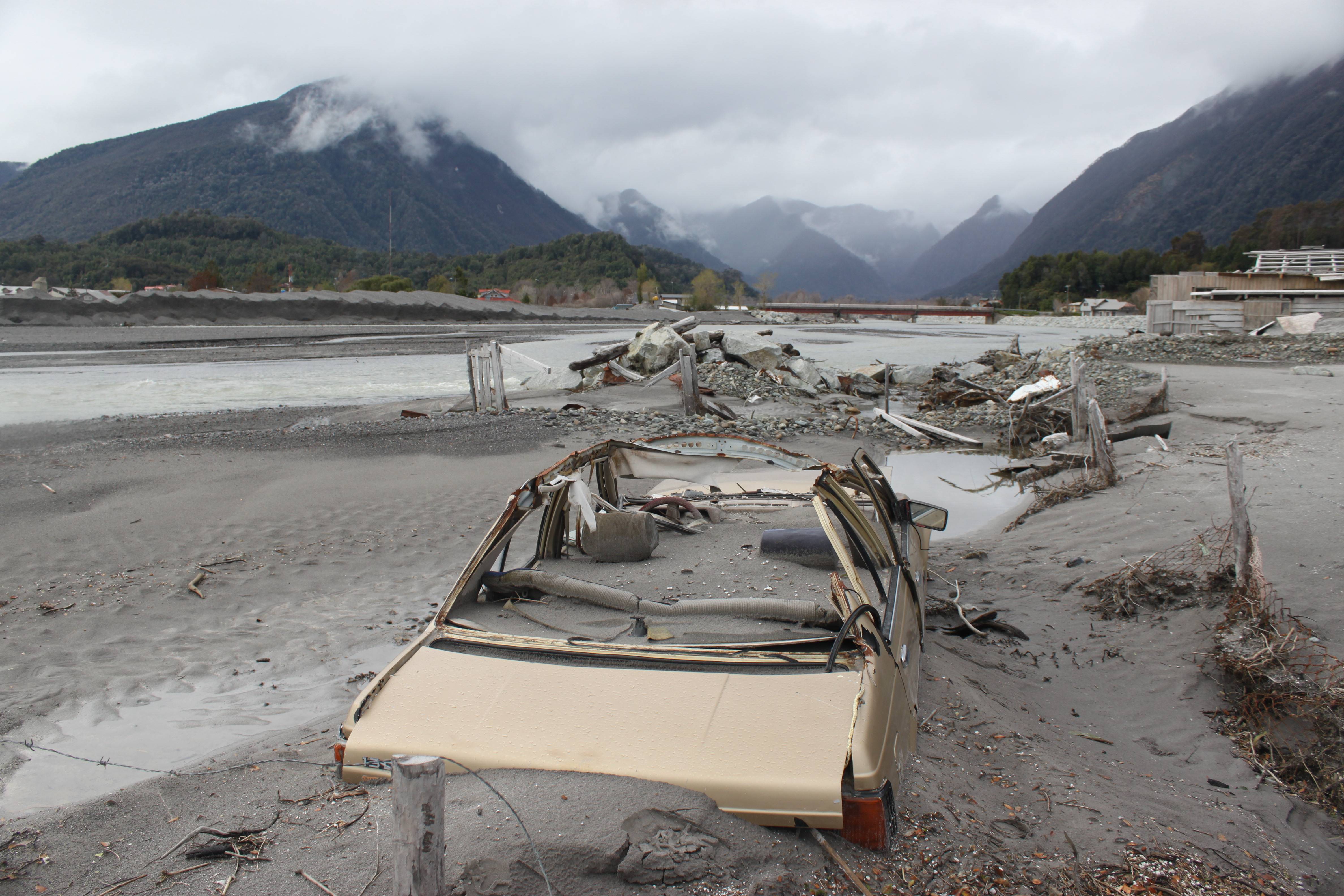
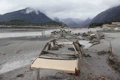
Submission by: Marie Crovisier, Centro de geofisica, Universidade de Evora, Portugal
The picture: Chaitén is a volcanic caldera 3 kilometres in diameter and 10 kilometres northeast of the town of Chaitén, near southern Chile. Radiocarbon dating of older tephra from the volcano suggests that its last previous eruption was in 7420 BC ± 75 years. On 2 May 2008, eruptive phase of the volcano began. Chilean government began an evacuation of the nearby town of Chaitén (population 4,200) on May 3. Beginning on May 12, lahars caused flooding in the town of Chaitén, depositing ash mud to a depth of up to a metre or more, damaging many buildings, and completely filling the original course of the Chaitén River past the town.
This is my favorite picture because: Imagine if there was not a monitoring?
Copyright information: Public domain.
Reference: The photographers are Marie Crovisier and Elodie Brothelande.
|
Constantinos Loupasakis
|
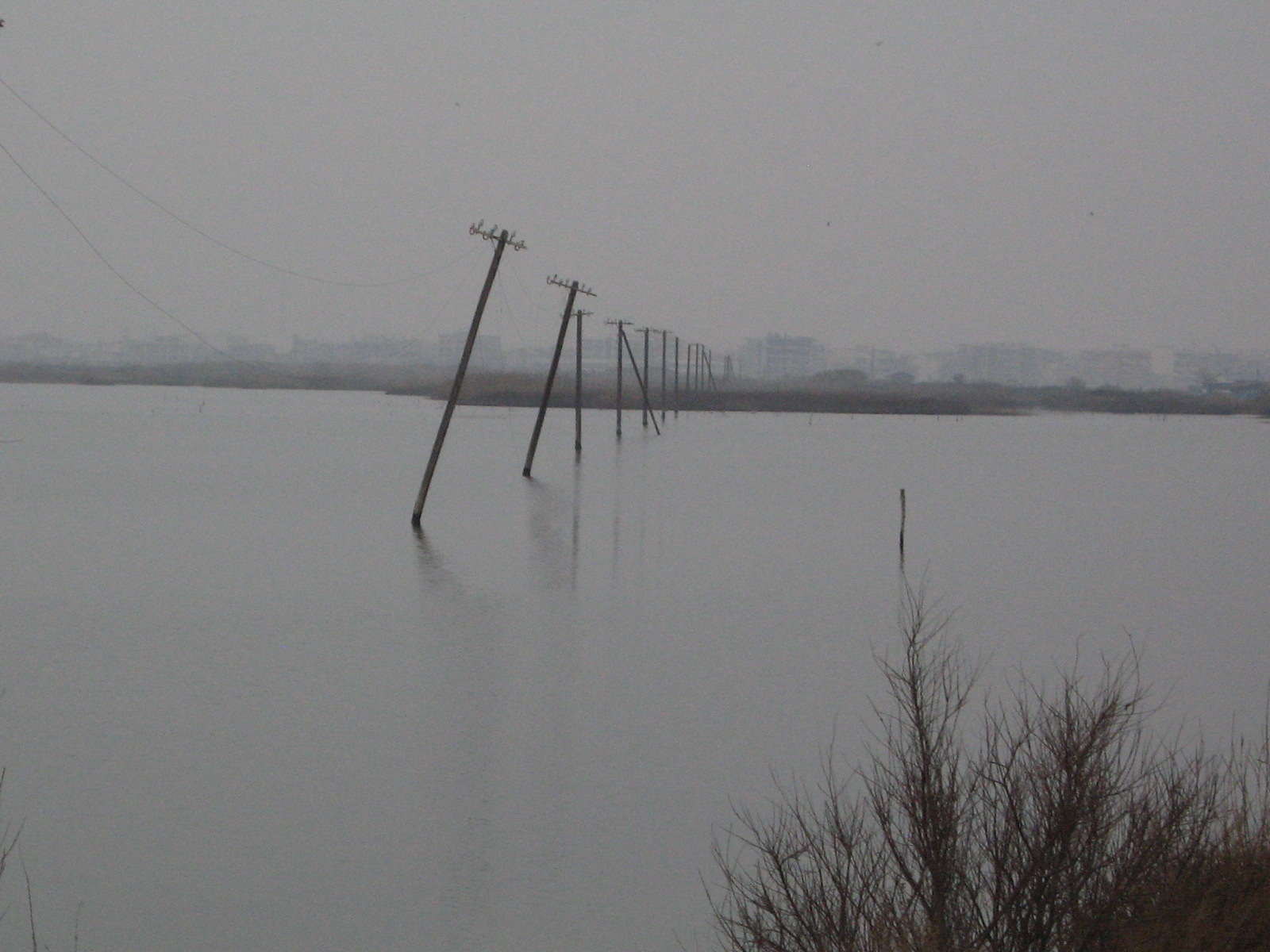
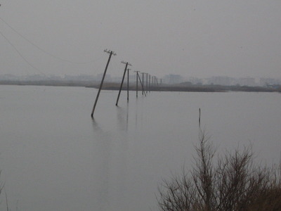
Submission by: Constantinos Loupasakis, National Technical University of Athens, School of Mining &
Metallurgical Engineering, Laboratory of Engineering Geology and
Hydrogeology, Athens, Greece
The picture: Submerged remnants of the old electricity network. Those poles were
installed along the side of a road constructed in the SW of Kalochori
village in 1975. The photo was taken by me in 2008.
Event specification: land subsidence phenomenon in Kalochori region,
Greece.
Land subsidence induced by intense water pumping or by reservoir
compaction has been occurring in several regions in Greece for more than
fifty years. One of the first noticed and variously studied land
subsidence phenomenon in Greece is that in Kalochori region. Kalochori
village was established in 1922, by refugees from Minor Asia (Turkey),
occupying the lowlands between the delta of Gallikos river and the west
side of Thessaloniki. The city of Thessaloniki lies in central
Macedonia, in the inner part of the Thermaikos Gulf and is the second
most populated city in Greece. In the 1960`s the financial status of
Kalochori village changed as its wider area became the main industrial
centre of the region. This rapid development led to the increasing need
of water, provided by productive wells. Furthermore, the
overexploitation of the aquifers was also enchased by the excessive
water pumping conducted by the Water Company of Thessaloniki. It should
be noted that, the aquifers of the riverside area of the down flow
sections of Galikos river, including Kalochori region, were the main
providers of drinking water in order to cover the raising needs of
Thessaloniki.
The subsidence phenomena in Kalochori region were first noticed in the
early 1960`s. Since then, the morphological and the environmental
setting of the region changed violently. The extreme land subsidence,
exceeding 3m locally caused the sea invention reaching up to the first
houses of the village. The embankments constructed for the protection of
the village reclaimed some of the lost land but at the same time they
allowed the generation of a shallow lagoon trapping the surface water
and the sea water infiltrated through the barriers.
This is my favorite picture because:
This picture comes from an area I started working when I was a student
back in 1995.
Copyright information: Public domain.
Reference: Photographer: Constantinos Loupasakis
|
Brian McAdoo

|
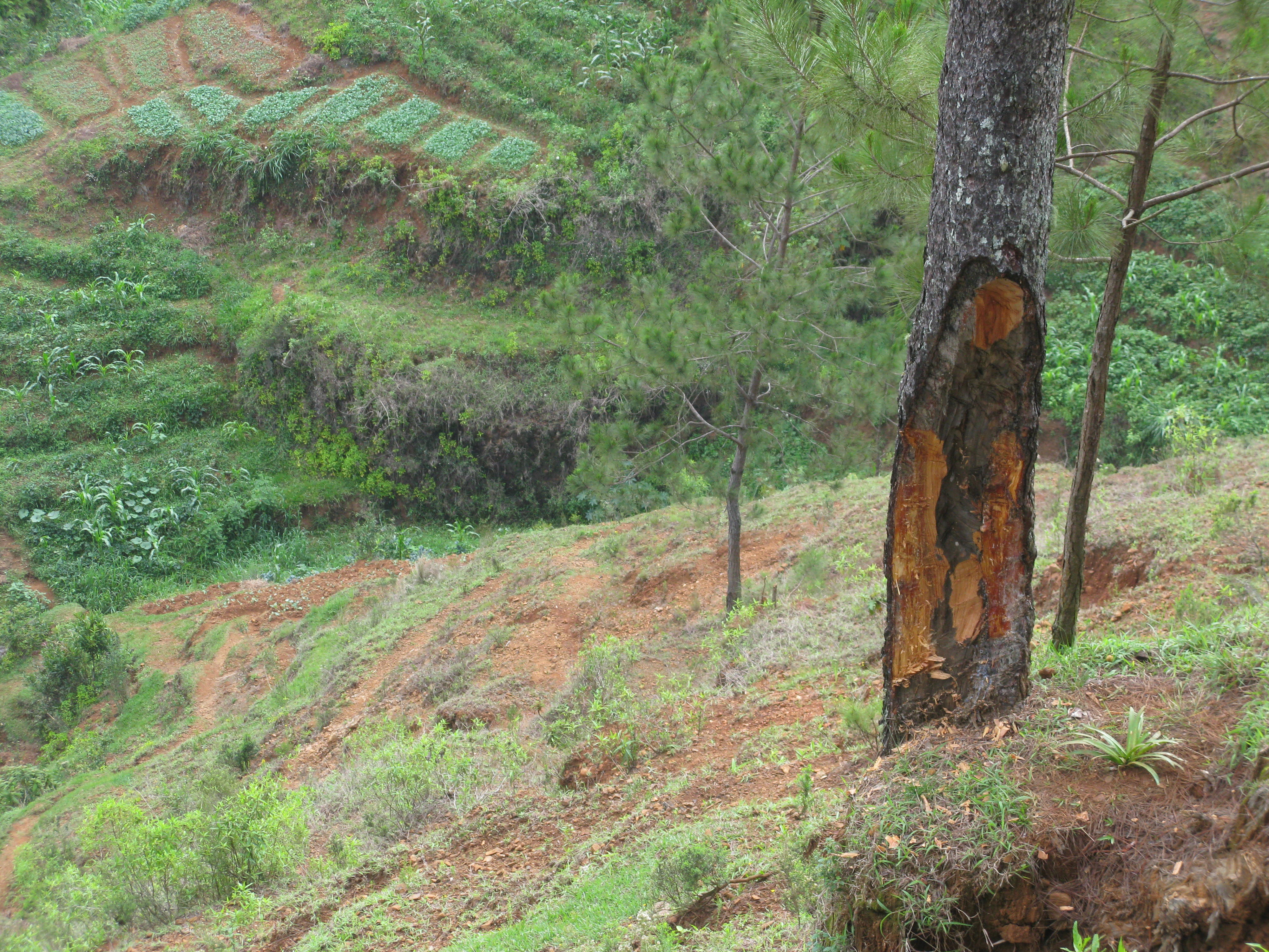
Submission by: Brian McAdoo, Vassar College, Poughkeepsie, NY, USA
The picture: Sustainable Poverty in Furcy, Haiti (May 2010).
This is my favorite picture because:
Two hundred years of post-colonial history added to the disaster that befell Port-au-Prince, Haiti on 12 January 2010. Farmers in the hills above Port-au-Prince know that trees stabilize the soil and moderate the climate, yet they still lack fuel to cook what little food they have. Instead of cutting down this tree, they chip away at it just enough to get the fuel they need, but without killing the tree and losing the ecosystem services it provides. It is this level of land degradation and poverty that lead to the rural outmigration to Port-au-Prince, resulting in high density populations living in the substandard housing that collapsed during the earthquake.
Copyright information: not available.
Reference: Not available.
|
Paraskevi Nomikou
|
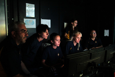
Submission by: Paraskevi Nomikou, University of Athens, Department of Geology and Geoenvironment, Athens, Greece
The picture: Watching the underwater magic world of the Hydrothermal Vent Field of Kolumbo Volcano, NE of Santorini.
4th of September 2011 in the control van of E/V “Nautilus”.
The Exploration vessel, NAUTILUS is equipped with Remotely Operated Vehicles (ROVs - underwater robots): Hercules and Argus, which explored the submarine volcano Kolumbo located 7Km NE of Santorini Volcano, Greece. It has a high bandwidth satellite system on board to facilitate remote science and education via the Inner Space Center (ISC) in the URI Graduate School of Oceanography and Exploration. On-line access to oceanographic research throughout the duration of the cruise was available through the webpage www.nautiluslive.org, where anyone could watch the on board processes and participate in discussions. The control room, located at the top deck of the vessel, is the place where scientists and engineers cooperate to conduct the survey.Throughout the expedition Nautilus was linked to schools of America, Greece, Italy, Spain, Turkey and Israel and the 'Nautilus Live Theatre' at Mystic Aquarium in Connecticut. USA.
This is my favorite picture because: Participating in such a cruise like Nautilus, gives me the opportunity to study underwater volcanoes and cooperate with scientists who have never met with before. Teaching my love for underwater volcanoes to students and small children is one of my first priorities. I stressed the necessity of prompt and proper information to residents Santorini as I was born in this volcanic island. Exploring unknown worlds has always been a challenge for me and I feel lucky to live this experience in the water. It is so nice to feel that you might be an inspiration to the children, dreaming to follow your steps, exploring the ocean with you.
This picture is my favourite one because it shows our suspense when the robotic vehicle systems (ROVs) explored the hydrothermal vents of the most active submarine volcano in the Mediterranean Sea. We were all contemplative in front of the screens in the control van, real-time watching and explaining to the audience about the structure and the history of the volcano. Kolumbo erupted explosively in 1650 AD and caused significant damage and fatalities on the island of Santorini. The eruption was strong and was accompanied by earthquakes and poisonous gases. The tidal waves reached up in a great distance from Santorini. It was amazing to watch hydrothermal vents constructed of massive sulfides and sulfates and covered by bacteria with vigorous gas emission and fluid temperatures up to 220ºC. One had the feeling that of being among them, being a part of the vent system!!!
Copyright information: not available.
Reference: The name of the photographer is Artemia Argyrou who covered photographic the mayors (Mr. Nikolaos Zorzos) visit on E/V Nautilus on September 4th 2011. During his stay on board Mr. Zorzos had the opportunity to have a tour and to explore the boat. He got familiar with the ROVs and he saw in practice how they work. He also saw how scientist co-operate and combine different science in order to achieve the same goal, the oceanographic research.
|
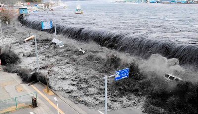
Seth Stein
|
Submission by: Seth Stein, Northwestern University, Evanston, IL, USA
The picture: The tsunami caused by the 7 April 2011 Tohoku earthquake crashes over a street in Miyako in northeastern Japan.
This is my favorite picture because:
Copyright information: Most likely, copyright is with Reuters. Permission to use has to be obtained from Reuters or New York Times.
Reference: The photographer is Mainichi Shimbun, who submitted the picture via Reuters. See NYT.
|
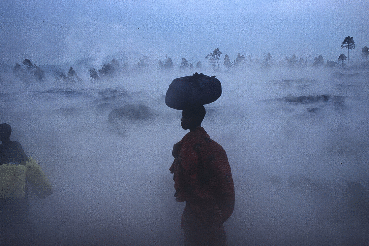
Dario Tedesco
|
Submission by: Dario Tedesco
The picture: Population escaping from the vapour coming out from the still hot lava where they are passing through after the January 2002 eruption of Mount Nyiragongo.
This is my favorite picture because:
Copyright information: Public domain.
Reference: The photographer is Dario Tedesco.
|
|