Background and Motivation
“Whatever is decided today is out-of-date by the time it is designed, tested, and implemented!” (Alan Edwards, 2012).
The design of … of the future must be very flexible and highly adaptive.
Challenge: Developing today the concepts for the technology of tomorrow!
Question: What are the basic characteristics of an information and management system based on tomorrow's technology?
- globally available and accessible;
- processing resources where the data sources are;
- scalable;
- best and next practices and workflows available to everybody;
- access to base datasets;
- updated in real-time;
- information density and quality increased through crowd sourcing.

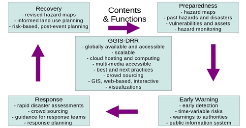
Figure 1: Functions and contents of the GGIS-DRR as they relate to the four phases of the disaster risk mangement cycle.

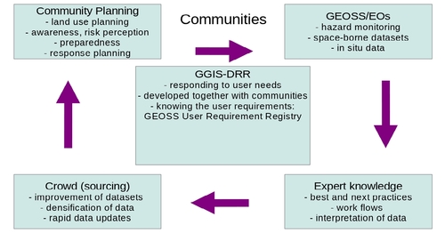
Figure 2: Communities involved in the development, populating, and use of the GGIS-DRR.
|
Some Characteristics
ADDITIONAL IMPACTS:
- equal opportunity: urban and rural; developed and developing;
- support focus on most relevant hazards;
- change risk perception;
- support improved decision making to access to information, intelligence;
- standardization, interoperability, data sharing
IMPLEMENTATION:
- provision of key resources through developed countries;
- web-based access provides global availability;
- scalable;
- community support (from state/national agencies, research groups, use cases)
- makes best/next practices available to others
PARTICIPATION:
- Task Team of DI-01 and GHCP;
- GEO Participating Organizations (POs);
- international and national agencies;
- non-governmental organizations;
- links to national and regional agencies through Member Countries of GEO;
- re-insurances;
- private industry (Esri, ...)
POPULATION THROUGH USE CASES, E.G.:
- Strain maps (global: UNR; regional: Nevada)
- Shakemaps (California, Nevada)
- Fault database (Nevada)
- Landslide data (Italy)
- Volcanoes (Italy and Democratic Republic of Congo)
- Land use planning based on hazard assessments (tbd)
- Tsunamis (tbd)
Progress towards the GGIS-DRR
Currently, the concept is developed.
|